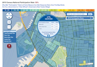
I hope that everyone’s mailed back their 2010 US Census forms, which are due April 1, National Census Day. While it’s a rather arcane approach to studying people’s location, it is still important because of its scale, use to allocate federal funding for community services, and use for updating electoral districts. One thing I really love about the census is that it’s mandated in the US Constitution, Article 1, Section 2, Clause 3.
Now that it’s 2010, they also have a interactive Google Map which display participation rate. Dubuque City, Iowa gets the gold star so far for a 70% return rate, which is well above the 52% national average. What makes this mapping project successful is that it raises questions (and potentially provides answers) about participation rates, location, and the allocation of resources, but in a way that is easier that reading at tables of the underlying data. They also provide widgets to display results.
However, what would really be great, of course, is if they released data sets to the public.


